On May 31, we hosted From The Vault: (Missing) Geographical Marvels
From The Vault is a biweekly event series showing collections objects selected by Leventhal Center staff with this week’s theme specially curated by our Reference and Cataloging Librarian, Lauren Chen! In this From The Vault, we’ll explore geography mistakes, unsupported cartographic features, and the history behind them. Just think of El Dorado, Hy-Brasil, the Mountains of the Moon! It’s difficult to imagine these fantastic places hiding right under our noses, but historic cartographers often made maps of places that only existed as hopes and dreams.
Jan Jansson Americae pars meridionalis (1644)

This map shows the legendary city of El Dorado, also known as Manoa, on Lake Parime at the top center. According to 16th century Spanish explorers and historians, El Dorado was a city or empire rich in gold and other valuables located in northern South America. Centuries of expeditions failed to find the city or lake, and in the mid-1800s the city was generally accepted to be a myth. There is current speculation that Lake Parime may have existed in ancient history or that it was caused by flooding.
R. H. Laurie Fredonia or the United States of North-America (1830)
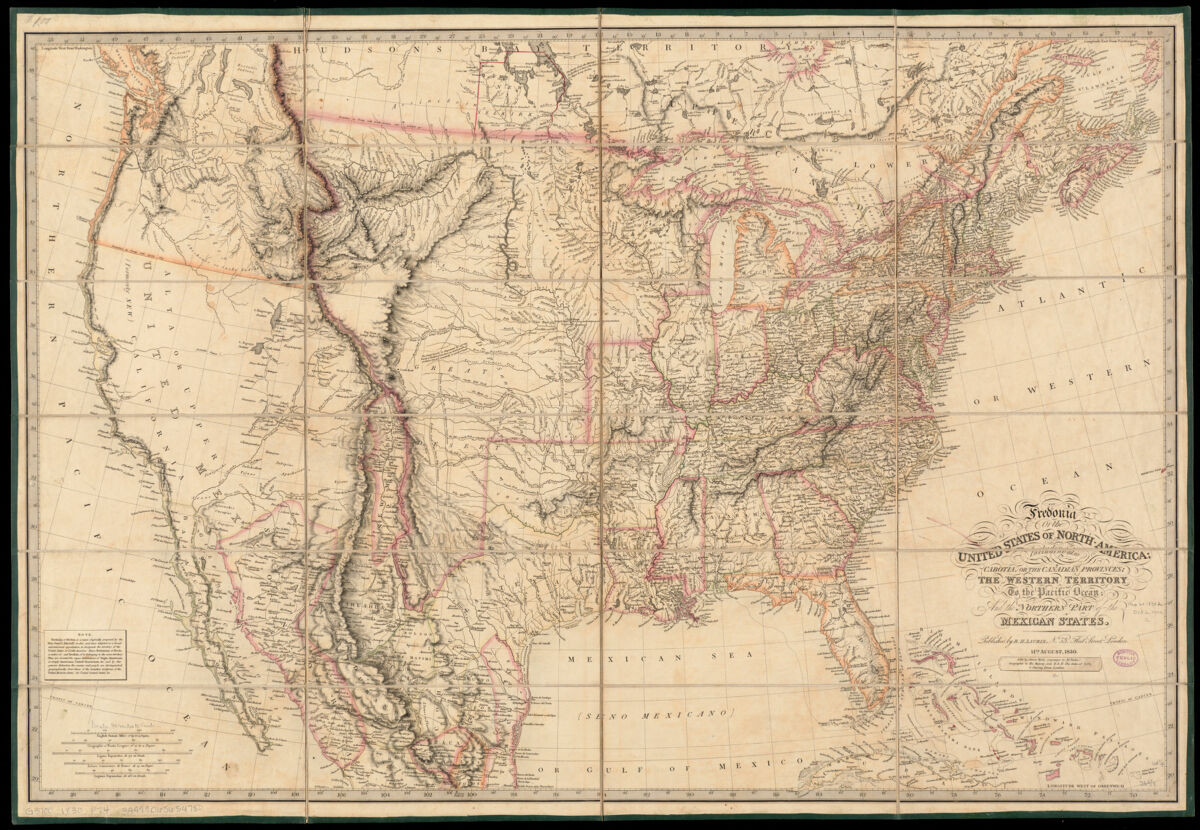
The Great Desert referred to an area west of the Mississippi River that was considered unfit for cultivation and therefore uninhabitable by people reliant on agriculture. Early 19th-century expeditions by the U.S. government reported a lack of surface water and trees, which they believed meant the region could not be farmed. The area was avoided by settlers passing through for the Gold Rush or aiming to settle in better lands in the West. When people settling in the area in the mid- and late 1800s received more rainfall than expected for a desert, they believed it to be a reward from God for settling the area or to be caused by their planting and plowing.
W. Scott-Elliot* Lemuria at its greatest extent *(1904)
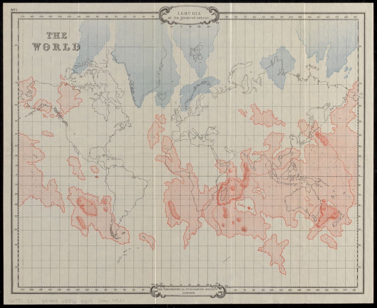
In 1864, the zoologist Philip Sclater proposed an ancient continent of Lemuria that had sunk beneath the Indian Ocean to explain lemur fossils in Madagascar and southern Asia but not in Africa or the Middle East. Theosophists, a religious group established in the United States in the late 1800s, claimed the continent was the home of the third “root race” or stage of evolution of humans. On this map, red outlines the continent of Lemuria while blue shows Hyperborea, the home of the second “root race” that preceded Lemuria.
Susanna Townsend Africa (1831)

This map, drawn by a schoolgirl in 1831, shows the non-existent Mountains of Kong in West Africa on the northern border of the “Coast of Guinea” and the equally fictitious Mountains of the Moon in East Africa on the northern border of Ethiopia. Ancient Greek and Roman geographers believed the Mountains of the Moon were the source of the White Nile River. The Mountains of Kong in West Africa were reported and drawn on maps by explorers in the 1800s. Both of these mountain ranges were common knowledge, appearing in encyclopedias and maps, and taught in schools until fading away in the late
Henri Abraham Chatelain Mappmonde ou description generale du globe terrestre [1705–1739]
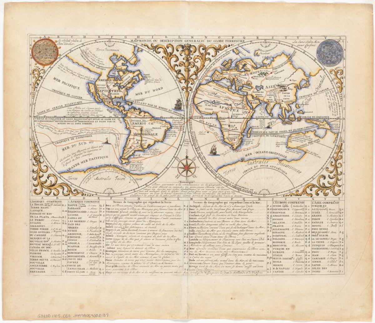
From the 15th to 18th centuries, people believed that the land in the northern hemisphere was balanced by a large unknown landmass in the southern hemisphere, often referred to as Terra Australis Incognita (Latin for unknown southern land). As explorers charted the southern hemisphere, the hypothesized continent morphed from connecting to South America, Africa, and Australia to being a separate continent and eventually believed to either lie within the polar regions or to not exist at all.
Gerhard Mercator Septentrionalium terrarum descriptio [1595]
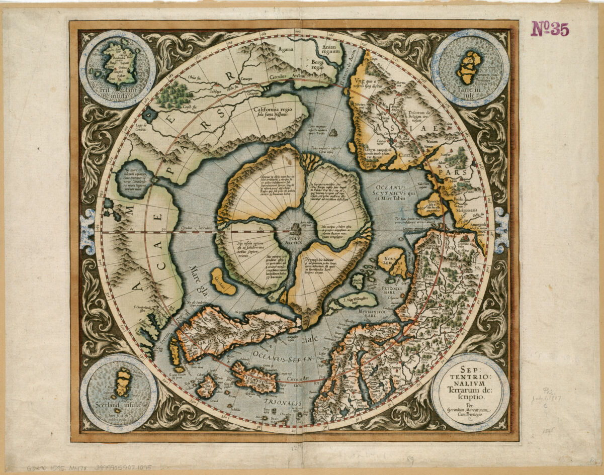
This map shows Gerhard Mercator’s idea of the Arctic region, based on his research of explorer accounts and other maps. It shows a tall black rock in the middle of a whirlpool formed by four rivers between four countries. The water in the whirlpool descends into the Earth like a funnel. While the black rock marks true north, another rock above it is the magnetic one to which compasses point, explaining the difference between true north and magnetic north. The map includes notes about the inhabitants of the four countries and other places.
John Senex*** A new map of America from the latest observations*** (1721)

This map shows two geographical misconceptions about the Pacific coast of North America. The Sea of the West, shown on this map as the Great Lake of Thoago or Thoya, was a large inland sea that appeared on maps in the 17th and 18th centuries. Juan de Fuca claimed to have sailed up a strait (possibly the current Strait of Juan de Fuca between Vancouver Island and Washington state) to the sea in 1592. This map also shows California as an island, which was possibly assumed by early explorers and spread as cartographers copied each other’s maps. By the 1800s, coastal and overland expeditions debunked these errors.
Willem Janszoon Blaeu Asia noviter delineata [1650]

Early accounts by Portuguese explorers in the 1500s described Lake Chiamay as an enormous lake in southeast Asia that was the source of many rivers in Bangladesh, Burma, and Thailand. The lake appears on this map to the lower right of the center, below the illustration of an elephant. The name likely came from the city of Chiang Mai in northern Thailand. The lake was included in maps, encyclopedias, and gazetteers up to the mid-1700s.
Robert Dudley ”Carta particolare dell mare di Ierlandia é parte di Inghilterr é della Iscotia” in Dell’ Arcano del mare (1646-47)

Phantom islands are islands that were purportedly seen by sailors and explorers and even appeared on maps for a time before later being deemed nonexistent. One of the most famous phantom islands is Hy-Brasil located west of Ireland and shown in the lower left on this map. In Irish legend, the island is constantly shrouded in mist and appears once every seven years. Some mariners claimed to have discovered the legendary island and reported fantastic accounts of otherworldly beings.
Our articles are always free
You’ll never hit a paywall or be asked to subscribe to read our free articles. No matter who you are, our articles are free to read—in class, at home, on the train, or wherever you like. In fact, you can even reuse them under a Creative Commons CC BY-ND 2.0 license.