On August 16, we hosted From The Vault: The Making of Maps.
“Cartography,” the practice of creating and studying maps, has evolved greatly over the last several thousand years alongside humans. As our understanding of the world around us has shifted, so too have the ways in which we are able to represent the world we’ve come to know. Throughout this process, countless different techniques have been utilized across many different cultures and time periods to be able to most accurately represent what we see around us. What did these processes look like, and which have ultimately proven to stand the test of time? We asked visitors to decide for themselves during “The Making of Maps” From The Vault!
Engraving (Woodcut Print)
Ptolemy, active 2nd century, Hol, Lienhart, and Johannes Schnitzer The world (1482)
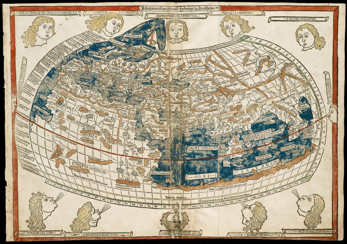
“The World,” is based on manuscripts from the Greek geographer and mathematician Ptolmey and provides a detailed look into what the ancient Greeks believed the Earth to be. Despite the original 2nd century manuscript of Ptolemy being destroyed, copies of these manuscripts existed in the 15th century around the same time as the popularity of the printing press exploded. This led Ptolemy’s “World” to be one of the first geographical texts ever engraved and printed.
Engraving is one of the first known methods of mapmaking on a larger commercial scale, and at this time was primarily done with wooden blocks in a method known as “woodcut.” This process involved carving away material from a wooden block to leave a raised image behind. The printers would then apply ink to the raised sections of the block, avoiding the carved out recesses, and imprint the ink onto paper; similar to how a stamp works. Oftentimes, the ink used for printing would leave a raised texture on top of the paper.
Etching
George Hartnell Bartlett The public libraries of Massachusetts (1904)

This map is a 1904 pictorial demonstration of the different public libraries across the state of Massachusetts designed through a process called etching. Etching is another printing technique developed about 100 years after woodcut engraving that allowed map makers and artists to add significantly more detail into their pieces. Similarly to engraving, etching involves carving a design into a plate and then pressing that plate onto a piece of paper.
The differences between the two lie in the process of creating the plate. Instead of carving away material from a wooden block, etching relied on covering a piece of metal in an acid-resistant material, drawing the desired design on the plate, and then dipping the plate into an acid bath to eat away at the drawn-on metal not covered by the initial coating. Afterwards, the plate is inked, and the ink is placed into the recesses of the plate as opposed to on top of the raised reliefs. It is then pressed onto a piece of paper to complete the printing process.
Joseph Frederick Wallet Des Barres A view of Boston (1779)

This is a 1779 bird’s eye view of Boston’s harbor intended to be used as a visual guide for visiting captains and crews that pairs alongside nautical maps. The method utilized to create this print is referred to as “aquatint.” Most often used in tandem with etching, the aquatint method leaves the acid resistant resin on specific areas of the plate for different periods of time, allowing for the acid to eat away at certain parts of the plate more than others. Because of this process, when the plate is later inked, specific sections can hold more ink than others, thus creating darker or lighter tones.
The development of etching and later aquatint allowed for the creation of significantly more complex designs in the printing and cartographic worlds due to the complexity of lines one could now create. Though designs could now be more complex, they were also getting increasingly more difficult and expensive to make due to the new range of materials needed for the process.
Hand Coloring
Japan. Rikugun. Sanbō Honbu. Ajia Tōbu Yochizu (1875)
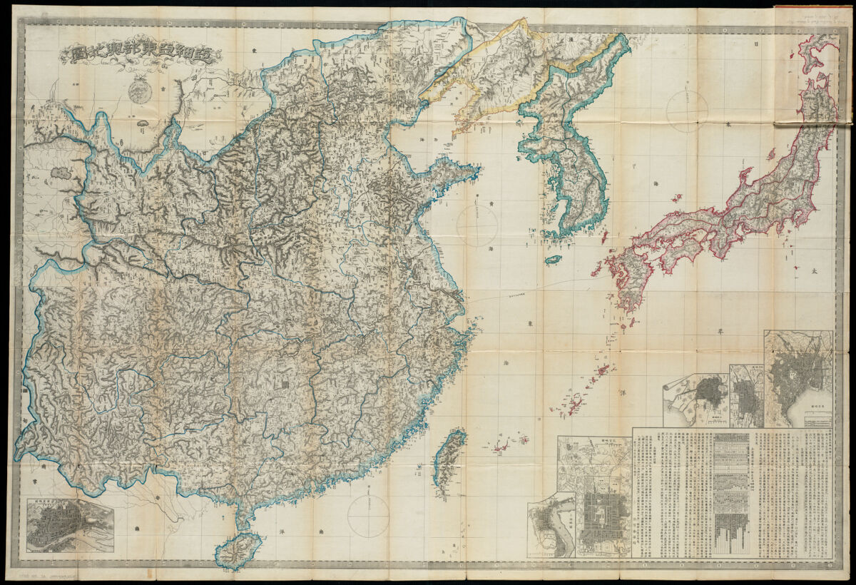
This 1875 military map of Japan was used by the government to refer to the population of the major cities across the country. Similarly to other maps shown today, it was created through the etching process—this piece was etched on a copper plate. Different from the other maps shown, this map has distinctive color running along the borders of each land mass. While Ptolemy’s world map was printed in color, the application appears somewhat crude as it was printed directly onto paper from the woodcut block.
In this Japanese map, a process known as “hand coloring” was utilized. Most maps before the 1800s were printed entirely in black and white, and had the option to be ‘colored’ as an upgrade. The hired “colorists” would source different pigments from across the globe, and carefully paint them onto the maps in faint washes to achieve the look their client requested. Most commonly, the borders of countries were colored for ease of use of the map later on, but many maps were lavishly decorated, making them beautifully painted art pieces in their own right.
Andreas Cellarius Planisphaerium Ptolemaicum siue machina orbium mundi ex hypothesi Ptolemaica in plano disposita (1661)
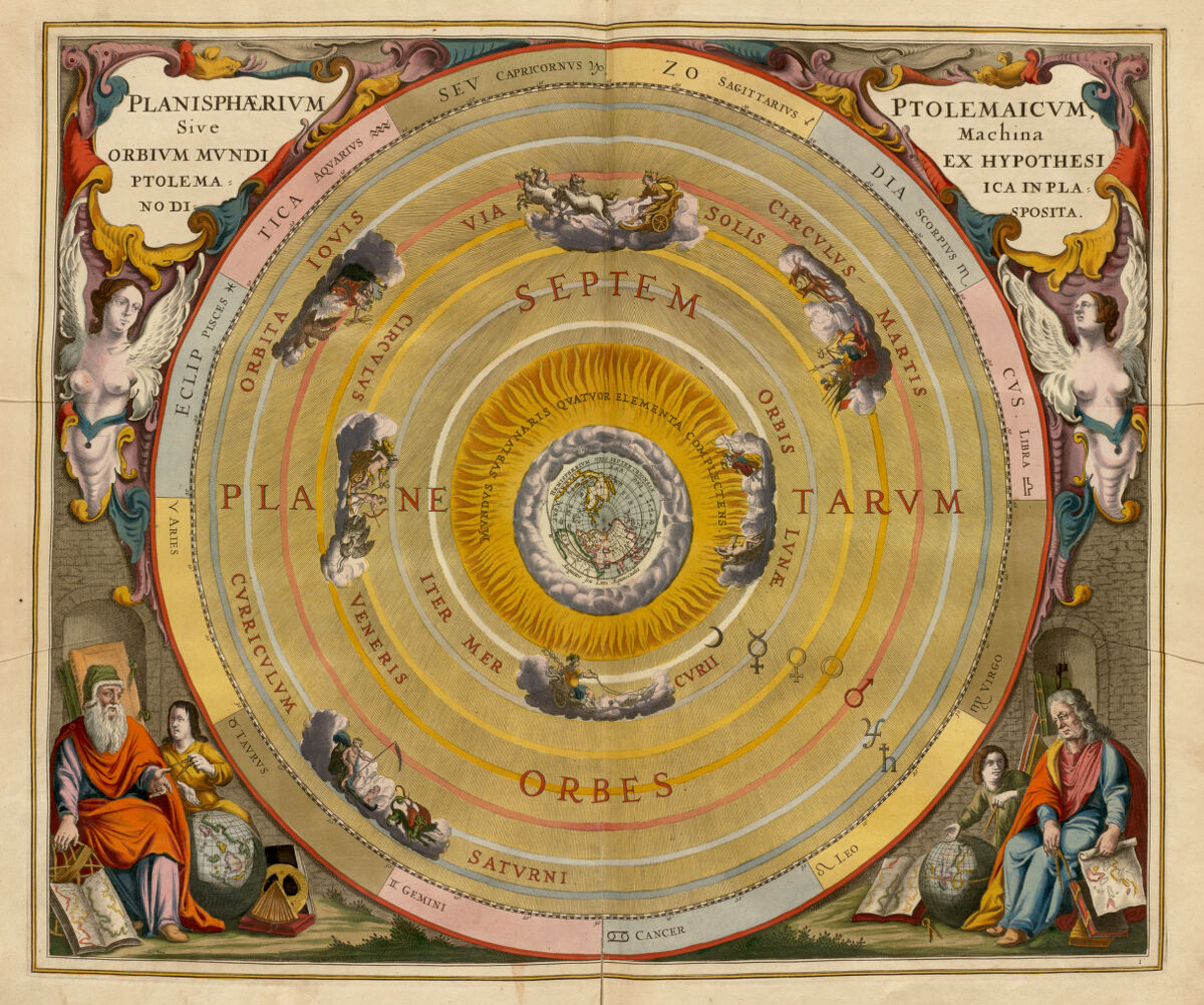
This stunningly colored celestial map from 1661 brings together the theories of many famous astronomers such as Ptolemy and Copernicus about the stars, the Sun and Moon, and the different planets in our galaxy. It is a beautiful depiction of the sheer breadth of coloring that could be achieved on maps and how colring was used both to emphasize the practicality and readability of the map as well as to present the map as a piece of art. With this map, a combination of techniques was utilized to give it its distinctive color palette. The engraving plates used to print this map held some color as it was printed, then a colorist later went on to add more depth to the piece.
Note how the color of this map is still so vibrant despite being nearly 400 years old. The artists responsible for coloring maps took great care to mix their pigments with different compounds that would not only maintain the integrity of the paper, but would also stay as vibrant and vivid as possible for as long as possible. With all the care taken to hand color maps and all the beauty it could achieve, the process was extremely expensive and few could afford pieces as intricate and colorful as these.
Lithographs
Elizabeth Shurtleff, Elizabeth L. McMillin, Helen F. McMillin A map of the Bermuda Islands (1930)
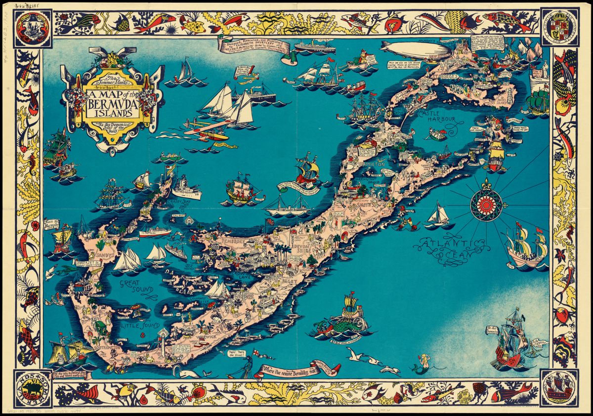
This 1930 pictorial map of the Bermuda Islands is a lavished colored tourists guide of the islands created by two female cartographers. It features a wide array of vibrantly colored cartoon figures and is jam packed with detail and artwork. This map was created through a process known as “lithography.” Several centuries after the development of etching and engraving came the lithograph, a process more similar to painting than any of the previous techniques.
When creating a lithograph, the artist draws and paints their design directly onto a stone block using an oil based medium, frequently crayon. The stone is then chemically treated and washed with water so that only the drawn on parts will absorb and hold onto ink. The stone is then inked in a similar fashion to engraving and etching, and pressed through a printer to adhere the design onto a sheet of paper. Colored lithographs were used, though not commonly as they frequently required multiple blocks and ended up being quite expensive.
Miguel Covarrubias Art forms of the Pacific area (1940)
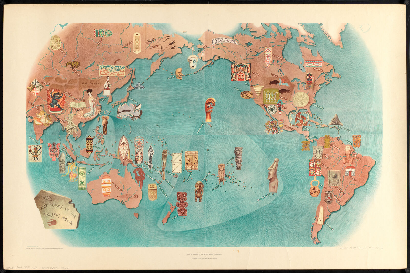
The 1940 lithograph shown here is a pictorial map of the pacific region encompassing Asia, Oceania, and the Americas that highlights the different artistic styles present in each region. It is done in a very lighthearted and cartoonish style and seeks to show off the culture of the land as opposed to just representing the land itself. This particular lithograph is known as an “offset lithograph” as the artist printed it onto another material before printing it onto its final piece of paper. This technique was used frequently so that the artist did not have to worry about drawing the initial design backwards to have it printed the correct way. Lithography as a technique was more commonly used than engraving due to ease, but as mass commercialization of the lithograph began, the quality of the maps produced with it began to decline. Despite advancements in technology since then, it is still commonly used in cartographic practice today.
Photography
United States Army Signal Corps, A. W. (Adolphus Washington) Greely, and United States War Department Progress map of Signal Corps telegraph lines & cables in the military division of the Philippines (1900)
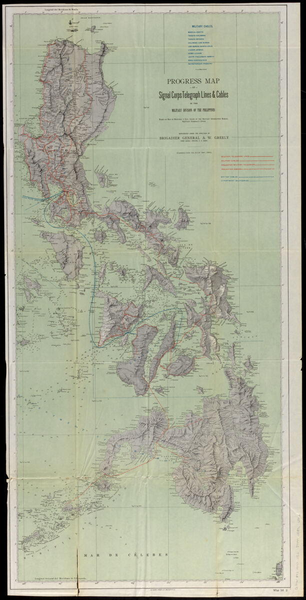
The 1900 map of the Philippines shown here was used as an informational piece by the military to keep track of the different telegraph and cable lines across the country. This map was also created through the lithographic process, though was done using a method called “photolithography” which began the transition from previous analog methods into cartographic methods more heavily shaped by technology. As photography slowly developed and advanced, its application in the process of creating maps became more apparent.
In photolithography, the same general lithographic techniques are used, though the image that would traditionally be drawn or painted onto the stone block is instead a photo transferred onto its surface. For the creation of photo relief maps, this technique was extremely useful to ensure accurate and precise information was being relayed. Photolithography was commonly used for military maps, and later became more widespread as technology advanced even further.
National Aeronautics and Space Administration, and Planetary Geology Program (U.S.). Shaded relief map of the Aeolis quadrangle of Mars (1984)
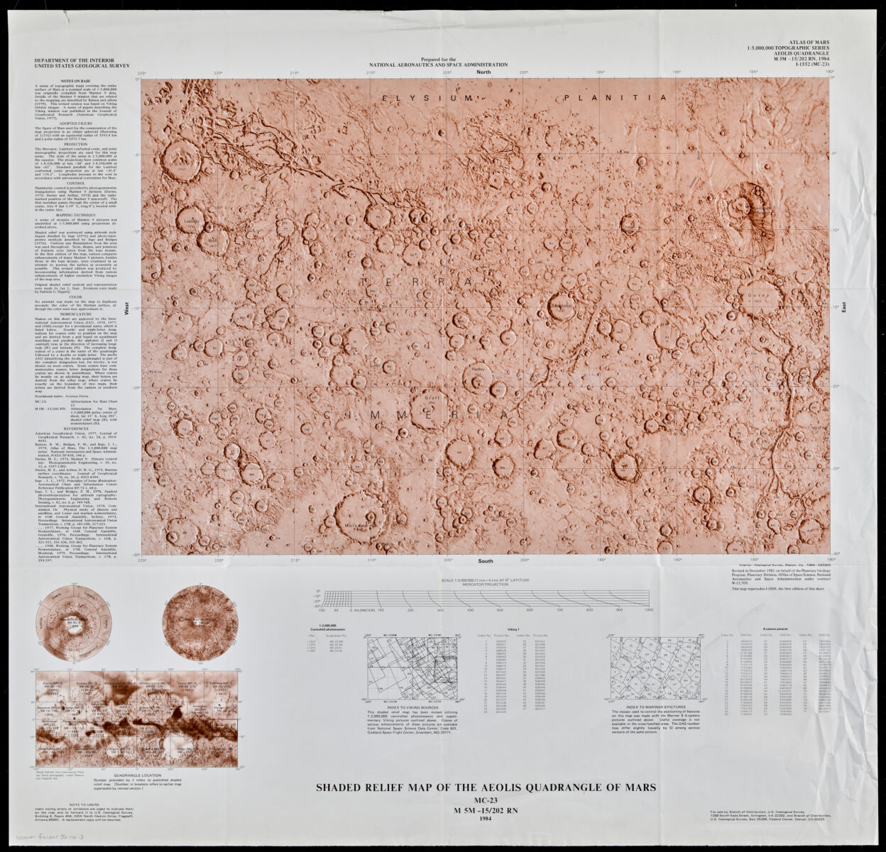
This map of the surface of Mars from 1984 depicts the rises and falls of the Aeolis quadrangle and maps out the texture of Mars’ crust. It is a photo relief map intended to specifically show texture and elevation on the surface of the planet. This photo relief map is merely a photograph of the surface of the planet, not created through any of the printing techniques previously mentioned. Instead of depicting a fully laid out section of the land like a traditional map would, photos obtained from rovers have been used to give us our best understanding of what the planet looks like. With the limitations that come from humans not being able to set foot on Mars ourselves, photographs have proven to be the best method of mapping the red planet that humanity has tried thus far.
Our articles are always free
You’ll never hit a paywall or be asked to subscribe to read our free articles. No matter who you are, our articles are free to read—in class, at home, on the train, or wherever you like. In fact, you can even reuse them under a Creative Commons CC BY-ND 2.0 license.